Beautiful Pakistan
rss
email
twitter
facebook
  • Home
  • Blogger Themes
  • Wordpress To Blogger

Archive for ‘December 2009’

K-2 (Chogho ree)

no comments
Posted on Thursday, December 24, 2009 by Ghulam Mehdi Amir


such as the Shyok River, Baltistan is situated on the high Ladakh Plateau and contains the loftiest peaks of the Karakoram Range—K2 (Mount Godwin Austen; at 28,251feet [8,611 metres] the second highest mountain in the world), Gasherbrum I (26,470 feet [8,068 metres]), and Broad Peak I (26,401 feet [8,047 metres]). Baltistan...


Emergency Numbers

no comments
by Ghulam Mehdi Amir

Chief Secretary, Gilgit-Baltistan Tel: (92-0572) 2501
Deputy Commissioner Tel: (92-0572) 2521
I.G. Police Tel: (92-0572) 2403
A.I.G. Tel: (92-0572) 2366
S.S.P. Tel: (92-0572) 2502
Airport Police Station el: (92-0572) 3266
Special Branch Police el: (92-0572) 3356
Intelligence Bureau Police Tel: (92-0572)2496
PIA Booking Tel: (92-0572) 3390
PIA Tower Tel: (92-0572) 3947
Airport Manager Tel: (92-0572) 2333


Photo Gallery

no comments
by Ghulam Mehdi Amir


Transport

no comments
by Ghulam Mehdi Amir


Prior to 1978, Gilgit-Baltistan was cut off from Pakistan due to the harsh terrain and the lack of accessible roads. All of the roads to the south opened towards the Pakistani-controlled state of Azad Jammu and Kashmir (AKJ) and to the southeast towards the present-day Indian-controlled state of Jammu and Kashmir. During the summer, people could walk across the mountain passes to travel to Rawalpindi. The fastest way to travel, however, was by air, but air travel was accessible only to a few privileged local people and to Pakistani military and civilian officials. Then, with the assistance of the Chinese government, Pakistan began construction of the Karakoram Highway (KKH), which was completed in 1978. The Karakoram Highway (KKH) connects Islamabad to Gilgit and Skardu, which are the two major hubs for mountaineering expeditions in Gilgit-Baltistan. The journey from Islamabad to Gilgit takes approximately 20 to 24 hours. Landslides on the Karakoram Highway are very common. The KKH connects Gilgit to Taxkorgan [disambiguation needed] and Kashgar in China via Sust (the customs and health inspection post on the Northern Areas side) and the Khunjerab Pass, the highest paved international border crossing in the world at 4,693 metres (15,397 feet).
Northern Areas Transport Corporation (NATCO) offers bus and jeep transport service to the two hubs and several other popular destinations, lakes, and glaciers in the area.
The Karakoram HighwayIn March 2006, the respective governments announced that, commencing on June 1, 2006, a thrice-weekly bus service would begin across the boundary from Gilgit to Kashgar, China, and road widening work would begin on 600 kilometres of the Karakoram Highway. There would also be one daily bus in each direction between the Sust and Taxkorgan [disambiguation needed border areas of the two political entities.
Pakistan International Airlines used to fly a Fokker F27 aircraft daily between Gilgit Airport and Islamabad International Airport. The flying time was approximately 50 minutes, and the flight was one of the most scenic flights in the world, as its route passes over the mountain Nanga Parbat, the peak of which was higher than the aircraft's cruising altitude. PIA also offers regular flights of Boeing 737 between Skardu and Islamabad. However, the Fokker F27 aircraft was retired after a crash at Multan in 2006. Currently, flights are being operated by PIA to Gilgit on the brand-new ATR42-500 aircraft, which was purchased in 2006. With the new plane, the cancellation of flights is much less than it was the Fokker aircraft. All flights, however, are subject to weather clearance, and, in winter, flights are often delayed by several days.


Education in Gilgit and Baltistan

1 comment
by Ghulam Mehdi Amir


Education plays a very important role in the socio-economic development of a society. It enables individuals to make informed decisions, improves their choices and develops their potentials to play productive roles in society. It also provides employment opportunities to low-income families and serves as a vehicle for social mobility, particularly for those who do not have other means of earnings. Experts believe that a minimum 70 per cent literacy rate is essential for initiating and sustaining economic growth and development in a society.
According to a Pakistan Social and Living Standards Measurement (PSLM) Survey 2006-7, the literacy rate of children aged 10-plus in Pakistan is about 55 per cent while the adult literacy rate of 15-plus population is about 52 per cent. The figures become disturbing when we see larger disparities between the rural and urban population and between males and females. The literacy rate remains higher in the urban areas than what it is in the rural areas and much higher in men than in women.
The adult literacy rate (15 years and above) in males is 65 per cent as compared to 38 per cent in females. Corresponding figures for urban and rural population is 70 per cent and 41 per cent, respectively. If the situation is compared with what it was a few years back, it can be seen that the literacy rate in Pakistan has increased at the rate of about one per cent per annum.
In the Northern Areas of Pakistan, the literacy rate seems to be increasing at a relatively faster pace. The Northern Areas of Pakistan constitute a single administrative unit, which was formed by the amalgamation of the Gilgit Agency, the Baltistan District of Ladakh, and the States of Hunza and Nagar in 1970. These areas or territories were under the administrative control of the Federal Government of Pakistan and hence called Federally Administered Northern Areas (FANA). The Northern Area Legislative Assembly (NALA) was managing affairs of these areas since 2002.
While honouring the sentiments and demands of the local people, the government of Pakistan recently awarded independent status to these areas and their nomenclature has also been changed to Gilgit and Baltistan. This is not just a change of the name, rather giving an identity to the local people. Northern Areas are comprised of six districts named Gilgit, Ghizer, Astore, Diamer, Skardu and Ghanche. The population of the region is about 1.5 million. Approximately 86 per cent of the population in the Northern Areas lives in the rural areas as compared with an estimated 66 per cent for Pakistan as a whole.
Although education is a provincial subject, but as the Northern Areas were administered by the Federal Government, hence the Federal Government itself was responsible for making provisions for education of children in these areas. According to a 1998 census, the adult literacy in Gilgit and Baltistan was about 38 per cent, which has now risen to 53 per cent in 2005-6 (males 64 per cent and females 41 per cent). This figure is slightly higher than the national figure of 52 per cent in 2006-7 (PSLM, 2006-7). At present Gilgit and Baltistan have a system of education comprising about 2,100 schools or educational institutions, including schools set up by the Federal Government, community-based schools, schools set up by Aga Khan Education Services (AKES) and other NGOs.
However, due to the physical features of these areas the provision of educational facilities in these areas has been a daunting task. Gilgit and Baltistan are isolated and happen to be most inaccessible mountainous regions with a harsh physical environment and severe weather conditions.

The first three primary schools in the Northern Areas were established by the Political Agent in as early as1893 in Gilgit, Astore and Gupis. Until the 1940s, the government was the sole provider of formal education in the Northern Areas. In 1946, the first 17 Diamond Jubilee Schools were established by the Aga Khan Foundation (AKF), which can be cited as a first community intervention in the field of education in these areas.
The history of female education in these areas is even more disheartening. Because they are far-flung and much at a distance from the rest of the country, there has been less awareness among the people about female education there. Consequently, female education has remained less in focus till about the 1970s. Gradually the local communities became aware of the importance of female education and a struggle for female education began mostly in Ismaili communities, particularly in the Hunza and Ghizer regions. In 1981, female literacy rate in the region was estimated under three per cent as compared to the 16 per cent total literacy rate in Pakistan. Even in the late ‘90s the educational indicators in the entire Northern Areas were reported to be among the worst in the country, and were especially low for girls and women. In 1994, the enrolment rate for girls was just 29 per cent as compared to the 60 per cent for boys. According to a 1998 census, the literacy rate was reported to be 37.85 per cent (male 52.62 per cent and female 21.65 per cent) in the Northern Areas. Female literacy rates in certain areas such as Baltistan were reported as low as 13 per cent.
However, there has been a drastic improvement in the recent years as a result of two interventions. Firstly, about 500 schools were opened under the Social Action Programme in the remote areas in mid-1990 and secondly, a 10-year-long Northern Pakistan Education Project was implemented by AKES with support from the European Commission.
It is because of such interventions, that education facilities have reached almost in each and every corner of the region. I have had the fortune to visit these areas very extensively and I have been amazed to see the establishment of two schools in a village very difficult to access that was situated within half a kilometre of the boarder adjoining Indian occupied Kashmir.


District Ghanche khaplu

no comments
by Ghulam Mehdi Amir


Khaplu is the Headquarters of District Ghanche and basic civic facilities are available. The main town of Khaplu is quite beautiful and worth visiting. Khaplu is spread in a radius about two square miles. One may find a mass of orchard around with abundance of apricot tress. River shyoke flows through the entire length of Khaplu town. A small bazaar exists in Khaplu and the necessary items of daily life are available here. One can also get transportation to every village and valleys of Ghanche from Khaplu. Khaplu has many historical places to visit i.e. Khaplu palace about 600 years old (under rehabilitation process by AKCSP), the famous Chaqchan Mosque and the Tomb of Mir. Following lines and picture give a flavor so much of the natural beauty in Khaplu.
Hushey Valley is the most attractive place to visit in district Ghanche. A chain of lofty peaks i.e. Mashabrum, K-6, K-7, K-12, Sherpikngh, Sia kangri, saltoro kangri, mt.Ghant, linksar, moonlight and many others more than 7000 meter exist in this valley. Thalley Valley is another beautiful spot. The lush green valley and beautiful scenery is marvelous. Ghanche has a number of beautiful lakes like: Kharfaq, Ghanche,Bara and Daholi Lakes which are matchless. Kharfaq Lake is situated about 3 Kms above Kharfaq village and gives an inspiring view while travelling by road to Khaplu. The fresh and crystal water lake is famous for trout fish and attractive location for camping and linking with other places. The lake is stocked with trout fish and one has to walk about two hours to reach the lake. A jeep road is under construction. Ghanche Lake is situated above Khaplu Town and is has not come to the lime light as yet. Bara is a Beautiful village abandoned of orchards and trees near Khaplu. There are two lakes situated in Bara one in Bara Paen and the other in Bara Bala.

Religion:
All the people living in Ghanche are Muslims and mostly people belong to Nurbakhsi Sufi branch of Islam whereas there are Shia Ithna-ashri Muslims as well. The Ulema play a great role in guiding people for religious matters. The scholar is religious leader called ‘Bowa’ in local language and has very important place in society.


Skardu

no comments
by Ghulam Mehdi Amir


Skardu is the main town of Baltistan along the wide bank of the river Indus. Skardu is the largest district of the Northern Areas. Baltistan is home to some of the highest peaks in the world, the Karakoram Range, Skardu is very popular with Mountaineering Expeditions. It is equally popular with high altitude trekkers, who treks to Baltoro Glacier, K-2 Base Camp and Concordia. Skardu by road, lies approximately 5 hours away from Gilgit and 10 hours drive from Besham. A daily flight to and from Islamabad is also in operation. The flight is always subject to weather.
Skardu has a character of its own and has a very interesting scenery. The Indus becomes wide and still here. The town is surrounded by dry rugged mountains and sand dunes.
Skardu is famous for the many trekking and adventure spots around it. There are numerous treks starting from Skardu. The near by Satpara Lake and Shangri-la resort are very famous among the local travelers and is visited by people from all over the country during June & July.


Trekking

no comments
Posted on Wednesday, December 23, 2009 by Ghulam Mehdi Amir


No doubt, North Pakistan is spirit of adventure, trekking in Northern Pakistan excite the imagination and the area are rugged are isolated places on earth. The combination of hospitable people, isolation and magnificent mountains scenery makes this is perfect place trek, provided one has a thirst for adventure, love for the innocent nature and strength to enjoy challenging walks.
Trekking in Pakistan is permitted to an altitude of 6500meters above see level and this activity is available in all regions of northern Pakistan throughout summer months, treks of all grades from easy hikes to strenuous walks on crevassed glacier and crossing of passes over 5000 meters are available.
Trekking trips oaf all grades are offered and duration of these trips stretches from 3 days to 30 days, depending on the choice, fitness and time available to the traveler.
Following regions/treks are located in open zone;

1 District Chitral: treks in Kalash valleys, Chitral Gol National Park, Shishi Gol & Golen Gol, Lutkhu valley, Laspur valley and Bashqar Gol. However, a permission from the office of the Deputy Commissioner, Chitral is required.
2 District Ghizer: treks in upper Ghizer River Valley, Yasin Valley to Yarkhun Valley and Yasin Valley to Ishkoman Valley.
3 District Gilgit: Bagrot & Haramosh Valleys, Naltar & Pakora Valleys.
4 Diamer District: Nanga Parbat region.
5 Hunza Valley: Nagar, Hunza proper, Gojal.
6 Baltistan: Basha, Tormik & Stak Valleys, Deosai Mountains and Plains, Biafo Hispar traverse, Thalle La & Tusserpo La and Aling Glacier & K-6 Base Camp.


Baltistan

no comments
by Ghulam Mehdi Amir


Actually a complex of beautiful valleys, is situated amid the famous ranges of Himalaya and Karakoram, straddling the river Indus, between Ladakh and Gilgit. Some of the highest peaks of the world - Chogo-ri (K-2), Mashabrum (K-1) and Gashabrum group of peaks besides beautiful glaciers like Sia-chen, Baltoro, Biafo and Chogo-lungma are situated in this region. The dimensions of Baltistan have been fluctuating over the course of history. It is currently smaller than ever before, with an area of 17,000 square kms. and an estimated population of 4,00,000. Baltistan consists of six major valleys like Skardo, Rongdo, Shigar, Khaplo, Kharmang and Gultari. Baltistan presents a beautiful contrast of high peaks, deep gorges, straddling glaciers, vast deserts, sandy plains, turquoise blue lakes, colourful panorama, lush green oases and villages.

Historical Prospective

The first reference about the area (Baltistan) occurs in the Epic of King Gesar (Kesar), but in a fragmentary shape. Reliable historical records date from the last days of Palolashahi rulers of Baltistan (Palolo) who, according to some rock-inscriptions, ruled the area of Ladakh and Gilgit too from the 5th century to 727 AD. In 727 AD the Tibetan king Khri-Lde-gtsug-bRtan invaded Baltistan and in 737 AD the Tibetans conquered Brushal (modern Gilgit) annexing these to their empire. These areas remained provinces of the Tibetan empire till the death of the last king of Tibet Glang-Darma around 880/900 AD, when the foremost western provinces, Baltistan and Brushal became independent. Since then till the 12th century AD, Baltistan remained under several petty chiefs under the overlordship of the Shagari-tribe of Skardo. In 12/13th century AD, a young fugitive namely Ibrahim Shah, migrated to Baltistan from Iran via Kashmir, managed to obtain power in Skardo and founded the Maqpon Dynasty which subsequently ruled the area for twenty-four succeeding generations. During the reign of ninth Maqpon ruler namely Ghota-Cho-Senge, one Saint Syed Ali Hamadani introduced Islam to the region. In 1531 AD Sultan Saeed Khan, the ruler of Kashgar invaded Ladakh and Baltistan. Ali Sher Khan Anchan the most powerful king, fifteenth in the kings of the Maqpon Dynasty, conquered Ladakh and Western Tibet up to Purang in the east and Gilgit and Chitral in the west during his reign (1590-1625 AD).
Similarly his grandson Shah Murad conquered all these areas for the second time between 1655-1680 AD. For about two hundred years all these areas remained tributaries to the Maqpoon kings of Baltistan. A comparatively new, more graceful culture and tradition of fine-arts flourished during this era. The Maqpon kings were great patrons and admirers of the new culture and society. In 1779 AD the Afghans of Kashmir invaded Skardo but could not sustain their control any longer. In 1840 AD the Dogras of Jammu conquered Baltistan and annexed it to their State, but in 1947-48 AD the area was annexed to Pakistan. However, Pakistan has maintained its status as the disputed area of Kashmir
Language & its origin

Language & its origin

The language spoken by the entire population of Baltistan is called -BALTI- which is an archaic dialect of Tibetan language. At present Balti has been heavily influenced by Burushaski, Turkish and Urdu and affected by Muslim literature in Persian. With the result, it has deviated from the original Tibetan language.


Mountains and Glaciers

no comments
by Ghulam Mehdi Amir

Five of the Eight-thousander (above 8,000m) peaks of the world are in the Northern Areas of Pakistan. Three of the world's seven longest glaciers outside the polar regions are also in Northern Areas, the Biafo Glacier, Baltoro Glacier, and Batura Glacier.
Some of the notable peaks include:
K2, 2nd highest of the world at 8,611m.
Nanga Parbat, 9th highest of the world at 8,125m
Gasherbrum I, 11th highest of the world at 8,080m.
Broad Peak, 12th highest of the world at 8,047m.
Gasherbrum II-IV, 13th-17th highest of the world at 8,035m-7,932m
Masherbrum (K1), 22nd highest of the world at 7,821m.
Rakaposhi, 27th highest of the world at 7,788m.


Climate of Gilgit Baltistan

no comments
by Ghulam Mehdi Amir


The climate of Gilgit-Baltistan varies from region to region, surrounding mountain ranges creates sharp variations in weather. The eastern part has a moist zone of western Himalayas but going toward Karakoram and Hindu Kush the climate dries considerably.
There are towns like Gilgit and Chilas that are very hot during the day in summer, yet cold at night, and valleys like Astore, Khaplu, Yasin, Hunza, and Nagar where the temperatures are cold even in summer.


The Gilgit Baltistan Geography

no comments
by Ghulam Mehdi Amir


Gilgit-Baltistan borders the Wakhan corridor of Afghanistan to the northwest, China's Uygur Autonomous Region of Xinjiang to the northeast, the Indian-controlled state of Jammu and Kashmir to the south and southeast, the Pakistani-controlled state of Azad Jammu and Kashmir to the south, and Pakistan's North-West Frontier Province to the west.

Until the war in North-West Pakistan, Gilgit-Baltistan was a major destination for foreign tourists, especially serious mountaineers, because it is home to five of the "eight-thousanders" and to more than fifty peaks above 7000 meters. Gilgit and Skardu are the two main hubs for expeditions to those mountains. The region is home to some of the world's highest mountain ranges—the main ranges are the Karakoram and the western Himalayas. The Pamir mountains are to the north, and the Hindu Kush lies to the west. Amongst the highest mountains are K2 (Mount Godwin-Austen) and Nanga Parbat, the latter being one of the most feared mountains in the world.

Three of the world's longest glaciers outside the polar regions are found in Gilgit-Baltistan — the Biafo Glacier, the Baltoro Glacier, and the Batura Glacier. There are, in addition, several high-altitude lakes in Gilgit Baltistan:


Subdivisions

no comments
by Ghulam Mehdi Amir


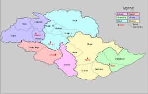
Gilgit-Baltistan is administratively divided into two divisions which, in turn, are divided into seven districts, including the two Baltistan districts of Skardu and Ghanche, and the five Gilgit districts of Gilgit, Ghizer, Diamer, Astore, and Hunza-Nagar. The main political centres are the towns of Gilgit and Skardu.


Autonomous status Gilgit-Baltistan

no comments
by Ghulam Mehdi Amir

On 29 August 2009, the Gilgit-Baltistan Empowerment and Self-Governance Order 2009, was passed by the Pakistani cabinet and later signed by the President. It granted self-rule to the people of the former Northern Areas, now renamed "Gilgit-Baltistan," by creating, among other things, an elected legislative assembly.

In early September 2009, Pakistan signed an agreement with China of a mega energy project in Gilgit-Baltistan which includes the construction of a 7000-megawatt dam at Bunji in the Astore District of the Gilgit-Baltistan.[8] This also resulted in protest from India, however Indian concerns were immediately rejected by Pakistan, saying the Government of India has no locus standi in the matter.

On September 29, Prime Minister Yusuf Raza Gilani while addressing a huge gathering at Gilgit-Baltistan announced a multi-billion rupee development package aimed at the socio-economic uplifting people in the area. Development projects will include the areas of education, health, agriculture, tourism and basic needs of life. The Prime Minister further went on to say:

"You are getting your identity today. It is your right and has been your demand, and today we are fulfilling it."


History of Gilgit Baltistan

no comments
by Ghulam Mehdi Amir


Before the independence of Pakistan and the partition of India in 1947, Maharaja Hari Singh extended his rule to Gilgit and Baltistan. After the partition, Jammu and Kashmir, in its entirety, remained an independent state. The Pakistani parts of Kashmir to the north and west of the cease-fire line established at the end of the Indo-Pakistani War of 1947, or the Line of Control as it later came to be called, were divided into the Northern Areas (72,971 km²) in the north and the Pakistani state of Azad Kashmir (13,297 km²) in the south. The name "Northern Areas" was first used by the United Nations to refer to the northern areas of Kashmir. A small part of the Northern Areas, the Shaksgam tract, was provisionally ceded by Pakistan to the People's Republic of China in 1963.

Gilgit-Baltistan, which was most recently known as the Northern Areas, presently consists of seven districts, has a population approaching one million, has an area of approximately 28,000 square miles, and shares borders with Pakistan, China, Afghanistan, and India. The people of this remote region were liberated from the Dogra regime of the former princely state of Jammu and Kashmir on 1 November 1947 without any external assistance and then became citizens of a self-liberated and very short-lived independent state. The new state asked the government of Pakistan to provide it with necessary assistance with which to conduct its affairs, as it did not have the necessary administrative infrastructure of its own. The government of Pakistan accepted the request and sent Sardar Muhammad Alam Khan, an extra assistant commissioner from the NWFP, to Gilgit. Sardar Muhammad Alam Khan then took control of the territory's administration as its first appointed political agent.

The local Northern Light Infantry is the army unit that was believed to have assisted and possibly participated in the 1999 Kargil conflict. More than 500 soldiers were believed to have been killed and buried in the Northern Areas in that action.[6] Lalak Jan, a soldier from Yasin Valley, was awarded Pakistan's most prestigious medal, the Nishan-e-Haider, for his courageous actions during the Kargil conflict.


Newer Entries »

Search

Google
Custom Search

Archives

  • ▼  2009 (15)
    • ▼  December (15)
      • History of Gilgit Baltistan
      • Autonomous status Gilgit-Baltistan
      • Subdivisions
      • The Gilgit Baltistan Geography
      • Climate of Gilgit Baltistan
      • Mountains and Glaciers
      • Baltistan
      • Trekking
      • Skardu
      • District Ghanche khaplu
      • Education in Gilgit and Baltistan
      • Transport
      • Photo Gallery
      • Emergency Numbers
      • K-2 (Chogho ree)

Followers

About Me

My photo
Ghulam Mehdi Amir
Student BBA(hons)
View my complete profile
free counters


  • Home
  • WP Blogger Themes
  • Wordpress To Blogger
Powered by Bloger | Designed by WebTreats
Converted by Wordpress To Blogger for WP Blogger Themes | Distributed by BloggerThemes | Blogger Templates